

In 2018, we made it through the Ferguson Fire without burning down and, in fact, with no damage whatsoever. No small accomplishment, though not through efforts of our own.
We get a lot of questions from guests about the evidence of forest fire they see while driving to our house. Someday we may add some articles on fire ecology and things like that, but for now, this is the story of how those burn areas along Wawona Road and Glacier Point Road came to be and what it was like for us.
Want all the gory details? Read on.
The Fire Starts
Whenever we go away in the summer, it is always with some anxiety.
Fire looms large in our minds as the creeks and vegetation dry out and news of California fires rolls in. Every summer, we think “This could be the one where we lose the house.” The idea of being away when that happens and not being able to grab passports and momentos encourages us to stay home during fire season.
For the last twenty years, though, I have gone to Michigan every other summer to teach my summer paleography workshop. This year, Theresa came with me so she could finally meet the folks I had been talking about for 20 years.
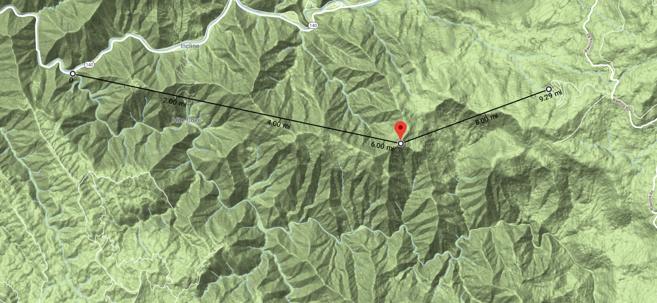
We left for Michigan on July 7, so on Friday, July 13, we were both away when we got news that a fire had started near Savage’s Trading Post. This is nine miles from our house, so it was a matter of some concern, but not major worry.
The only real problem was that early on the fire burned the main power lines to the region and we had guests in Alpine Escape. This is only the second time we’ve had a major event while we were away and fortunately, in both cases, our guests proved themselves to be self-reliant and adaptive people.
It was disappointing for our guests, but not yet the fire we had always feared — the one straight down the hill from our neighborhood. But that would come.
The next day, we found out that a firefighter had died, bulldozer operator Braden Varney, a well-liked local resident and friend of a friend. After the first 24 hours, the fire had expanded to 828 acres and was still many miles away.
Could it possibly reach Yosemite West?
The Fire Grows
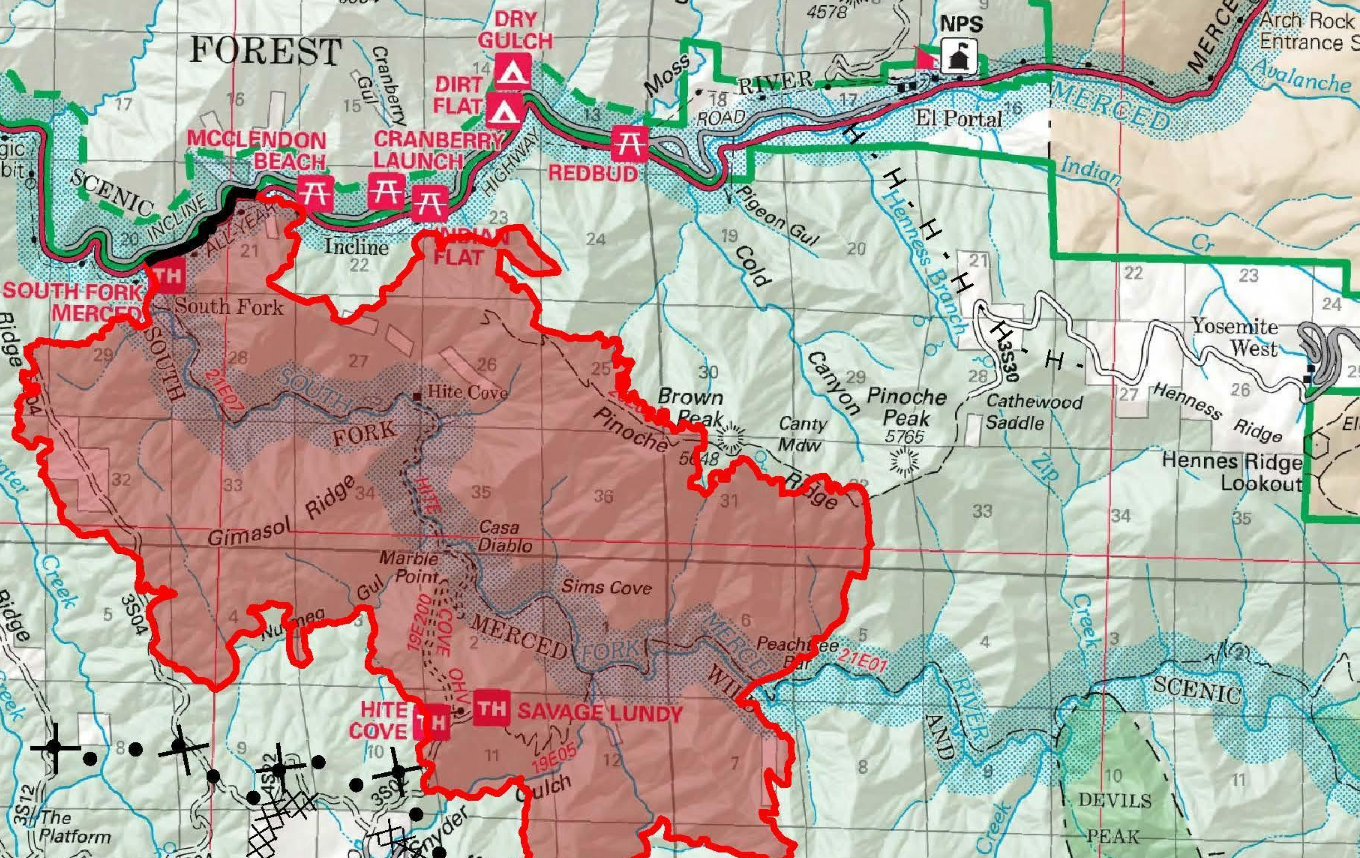
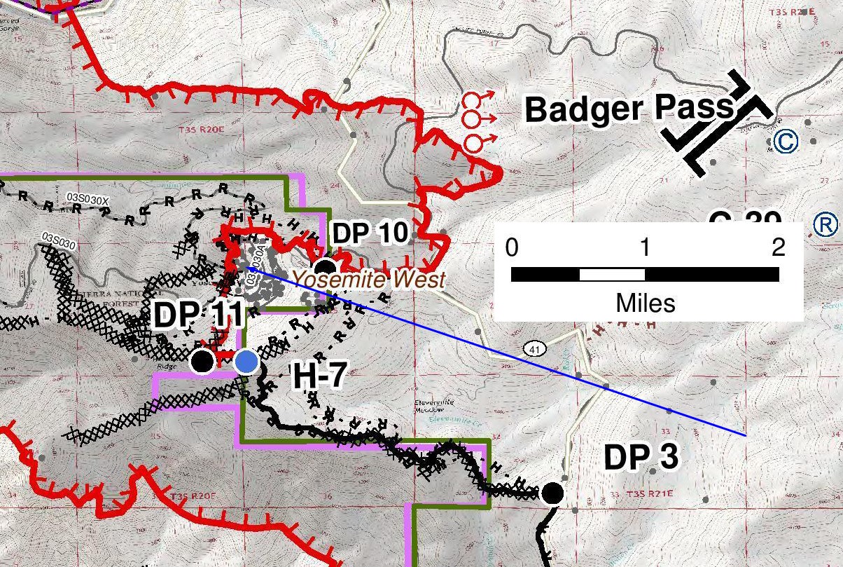
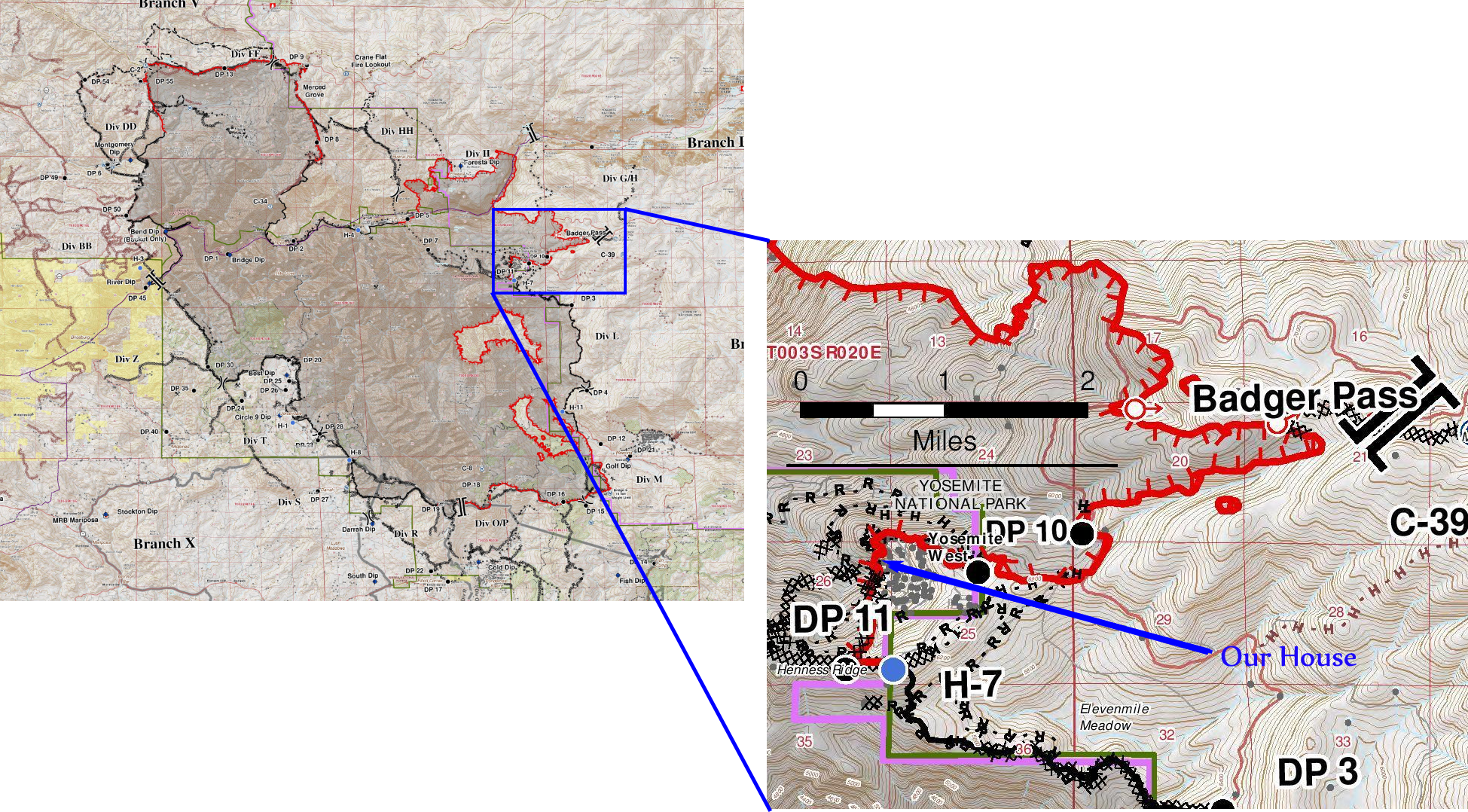
By the time the morning map came out on July 17, representing three days of activity, the fire had covered six of the nine miles to our house and was lapping Pinoche Peak. There were now three miles and one ridge between the fire and our home.
Four days later, our neighborhood was placed under an evacuation order. By this time, we had left Michigan to spend a long weekend with Theresa’s parents in Minnesota. We cancelled our flight, not realizing that our long weekend would last 24 days!
Before the evacuation was mandatory, several kindly friends offered to swing by the house and grab things for us. Eventually, two neighbors actually came to our house and fully loaded our pickup truck and drove it to safety. It was more than we would have dared to ask, as their house was threatened too and they had plenty on their minds.
There were nearly a dozen evacuated communities and, finally, on August 3, they ordered the evacuation of Yosemite Valley, only the second time in history that Yosemite Valley was evacuated due to fire. There are four substantial residential areas that are inside the park gates: Yosemite Valley, Wawona, Foresta and Yosemite West. With the mandatory evacuation of Yosemite Valley, all four were now evacuated.
The last time the Valley closed due to fire, in 1990, that fire would ultimately destroy many of the houses in Foresta and Yosemite West narrowly escaped due to a shift in the wind.
Would this fire destroy Yosemite West?
Firefighters Draw a Line in the Forest
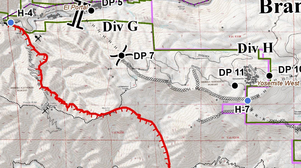
By July 24, things were looking positive. The fire was fully established on Pinoche Peak and in the drainage below Henness Ridge, the ridge right above our neighborhood. But firefighters had built dozer and hand lines all the way along their primary defense line on Henness Ridge. There were over 3,000 firefighters deployed. Things looked good.
(source: Inciweb)
Backburns
Over the next few days, the firefighters backburned along the entire line, starting at the top and working their way all the way down to Highway 140.
Backburns, or “tactical firing operations” as the fire people call them, widen and strengthen the line. Initially, they create a line anywhere from a handline the width of a narrow hiking trail to a dozer line the width of a road.
A fire can easily jump a line like that. So they try to wait until they have winds blowing away from the line, and then the set a fire using drip torches and a gas/diesel mix. Ideally, the wind pushes the fire away from the line and toward the main fire. The goal is a relatively low-intensity fire that will broaden and strengthen the line as it burns out fuels. When the main fire hits the burned out line, it is starved for fuels, runs out of strength and can be held there.
That’s the theory anyway.
In reality, a hot fire creates massive updrafts that throw embers high into the sky. On a recent hike at least a quarter mile from one of the backburns, we found the forest littered with charred bits of bark that had been wafted on the wind, but fortunately did not “spot” across the line. In extreme cases, a hot fire on a bad day can spot as much as a mile across the line.
This is why wildfires commonly leave a burn pattern that is a “mosaic,” a patchwork of burned and unburned areas. Sometimes, within the boundary of the fire, the vast majority of the area is burned only in the understory and large sections of many acres are not burned at all.

(source: Inciweb)
Back on the Line
By July 28, with firing operations complete along the line protecting our area, things were looking good and we got ready to return home.
We had dodged the bullet. Or so we thought.
Then, the fire operations map for July 29 showed a small bulge outside the containment line. The fire had slopped over the line and because of thick smoke due to a strong inversion layer, the firefighters had not noticed it.
The morning briefing was optimistic. They had crews in there and expected to contain it.
The rumor mill was saying otherwise.

Tragedy on the Line
Then tragedy struck. While cutting down a tree to contain the fire, the tree took an unexpected bounce and killed Brian Hughes, the much-loved leader of the Arrowhead Hotshots. This incredibly sad event, right in our area, cast a pall of sadness over the future successes.
With the forest thick with dead trees from bark beetle infestation and rocks rolling downhill, it was too dangerous to risk another life. So the crews pulled out.
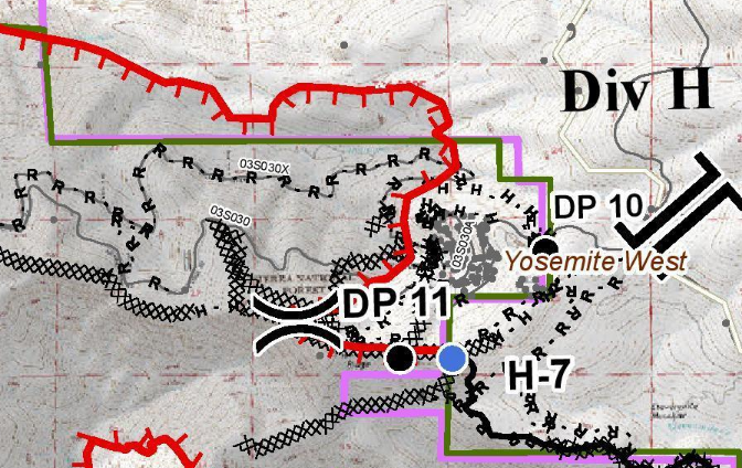
With the inversion holding the thick smoke low and preventing pilots from seeing through it, there was no air support. They made the decision to let the fire run, hoping to stop it at road 03SO30X. We bike this road pretty often and estimated the chances of making a successful stand there as close to zero — it is a one-lane logging road where the trees branches often bridge from one side to the other.
Game Over for Yosemite West?
Over the next couple of days we watched as the fire approached road 03SO30X. On August 2, we anxiously waited for the day’s fire operations map to post online and saw that the fire had jumped the road and was now straight downhill of our neighborhood in dense forest with no significant barrier between it and our homes.

It looked like it was game over for Yosemite West.
Firefighters Make a Stand
Unlike 1990, this time, however, they had had three weeks to prepare a line on Henness Ridge, secure some exits routes, thin in the neighborhood. Also, over the past 12 years, residents have made a concerted effort to make our area more fire safe. Plus, the inversion was still slowing down the fire.
The firefighters decided to stay and fight.
I had never expected that decision and I would never has asked it of anyone. But the professionals on the ground had been planning for this night for three weeks and felt comfortable with their plan.
Now they just had to fight the fire they had always said they would not be able to fight. No big deal.
They fell back to their contingency lines, some quite close to the community. A firefighter told a friend who was in the neighborhood, “We’ve got a lot on the line tonight.” So, taking advantage of the nightly downslope winds, they walked into the forest and started setting fires along the contingency lines to burn out the fuels in advance of the oncoming fire. There are countless ways in which this could have gone wrong, but inaction meant almost certain destruction. Afterwards, I told the fire chief, who had spent most of her career in fire forecasting, that I never thought it would work. She just smiled and said, “Yeah, me neither.”
All night long they set fires and then worked to keep them out of the neighborhood, watching for spot fires and generally keeping the fire from jumping the lines once again. The big question now was “Were the lines deep enough to hold off the flame front when it arrived?”


August 2-3: Tactical Firing Operations (source: Keith Guy)

August 2-3: Tactical Firing Operations (source: Keith Guy)

August 2-3: Tactical Firing Operations (source: Keith Guy)
The Fire Arrives
After three weeks of nervous anticipation, late on August 3, the main flame front finally arrived at the Yosemite West lines.
Fortunately, in most areas close to the neighborhood, the fire did not crown. To the south, the fire made a hot run up toward Henness Ridge. To the north, it made another hot run. Firefighters witnessed a fire whirl (aka “firenado”) race up a drainage near Avalanche Creek. One of the firefighters who also happens to be our dental hygienists nephew, captured a fire whirl on video not too far from our area.
The northern run jumped the Wawona Road and then in short order raced uphill and jumped the Glacier Point Road. If any of these hot runs had come straight at Yosemite West, I would likely be writing a very different chronicle at this point.
The fire also jumped Highway 140 and made a run toward the community of Foresta. To the far north, the fire encroached on Highway 120 west of Crane Flat. That meant Yosemite Valley was cut off from all three western exits, leaving only Highway 120 over Tioga Pass open.
With Wawona Road and Glacier Point Road compromised, firefighters were cut off from their “spike camp” at Badger Pass and had to shelter in place in our neighborhood. This is exactly what they could not have risked if residents hadn’t spent the previous 12 years reducing the fuels in the neighborhood and firefighters hadn’t had three weeks to make additional preparations.
It is hard to describe just how much luck we had on our side.
An Anxious Night
As the fire passed to the north, one resident who stayed said that you could hear the roar of the fire all night long. We knew this was the big show.
We had done pretty well at going about our daily business, keeping up with our work remotely, enjoying dinner with family. This night, we fell asleep late, slept fitfully and awoke early, expecting that when the news of the day came, our home would likely be gone. Being two hours ahead, though, it was a long wait until the morning report came out.
Structures Lost
When the report finally came out, it updated the number of structures lost from one to eleven. We assumed that the neighborhood had been lost and that the low number was just a delay in reporting and that as the day wore on, the number would climb and bad news would roll in.
Slowly, we heard rumors that no houses had been lost that night. Finally, in the evening update on August 4, we read, “Fire burned to the north, east and west of Yosemite West. Firefighters were successful in protecting structures and ignited tactical fires to buffer both communities” (that is, Yosemite West and Foresta).
It turned out that a handful of abandoned mining shacks on the other side of the fire had been lost.
Out of Danger
By August 6, we were hearing fire managers finally say that they thought the danger to Yosemite West was past. There were still threats in Foresta, but generally, things looked good there.
We could finally really enjoy the family time we had left before going home.
Before the highway by our house could reopen, there was a long process of lighting backburns all the way down the Wawona Road to Elephant Rock, a defensible ridge that would let them reliably stop the fire before it entered Yosemite Valley.

There were also hundreds of hazard trees along the roads that had to be felled and countless hours of labor in improving safety and getting fire restoration crews into the areas that had been churned up by dozer lines and hand lines.
But for the communities involved, the stressful part of the fire was effectively over.
The next day, they lifted the evacuation on Yosemite West and we bought plane tickets to return from Minnesota on August 13.
What would we find?
People kept asking us how we would deal with smoke damage and things like that. We didn’t know.
Coming Home
We finally made it back home on the afternoon of August 14, after going into Yosemite Valley to pick up our truck that kindly neighbors had packed and driven out for us. A small section of Hwy 140 was very smoky, but mostly the forest looked good, with nice burning in the understory and very little crown fire.
The normalcy of everything was uncanny.
Within the neighborhood, everything looked as it had before we left. Standing on our porch and looking out, you could see no signs of fire except for charred pieces of ponderosa pine bark littering the ground everywhere, having been hurled high into the sky on the fire-fueled updrafts. Nothing told of the pitched battle that had raged there just ten days earlier. It all felt surreal.
We braced ourselves for smoke damage, but the worst of it for us was that our house had been closed up for 39 days in hot weather and smelled stuffy.
We expected to be hunkered down hiding from the smoke, but instead, we opened the windows and turned on fans to let the fresh air in and slept with the windows open. We couldn’t believe it.
But every rush of joy turned our thoughts to the families of Braden Varney and Brian Hughes and the fact that two men had died in the effort to fight this fire, one specifically in the fight to save Yosemite West.
Right across the street from our house, we found a new “trail.” That is to say, they had dug fallback handlines right near the house. As this was more of an emergency fallback line, it was all unburned around it and we walked it just for a look.
We were dubmstruck by the amount of effort that had gone into building that line and others around the community. This doesn’t count the miles of line that were on the edge of the fire and the miles of line that were eventually overrun. In addition to all the lines, they also laid out 85,000 feet of firehose. Again, it is hard to quite wrap my mind around the effort just to save some houses.
Aftermath and Recovery
It wasn’t until August 24 that the Wawona Road opened and we could drive through the hottest part of the burn area. It was a staggering contrast to the normalcy of our neighborhood and the Wawona Road in the other direction (toward Wawona). For about two miles, the bulk of the forest had burned.
In general, the forests of the Sierra Nevada must burn to stay healthy and the vast, vast majority of the area burned in this fire saw the healthy, low-intensity fire that rejuvenates the landscape. But the area where the fire had made the hot, fast run on August 3-4 was absolutely scorched.
But again, the ecosystem here has evolved not just to survive fire, but to need it. Many species simply cannot reproduce effectively in the absence of fire. Some seeds require heat or smoke exposure to germinate. They lie in the soil for up to 100 years waiting for a fire. Other species can sprout from their roots even with the entire part above the soil is burned.
We walked one of the dozer lines about two weeks after the fire had passed and saw oaks putting up new shoots around the stumps. The bitter dogbane was sprouting and flowering, while outside fire area, the same species was turning yellow for fall. We saw large numbers of tracks from bears, mountain lions, coyotes, foxes, small mammals, lizards and snakes in the dusty ground, sometimes right in the ashes. Over the next few days we spotted two bears walking the edge of the burn area. Many oaks were dropping acorns early, which is good news for bears.
We are looking forward to doing some fire phenology and see what blooms when and what comes back first.
[2019 update: the spring of 2019 brought the most astounding wildflower displays we’ve ever seen — carpets of blue and yellow and white throughout the burn area]
The Kindness of Neighbors
The Efforts of Strangers
During the entire time, we were philosophical about losing the house. But we realized that we would also lose a community. The fire coming while we were away meant we depended on friends and neighbors to take care of things we would have taken care of ourselves under other circumstances. Countless people offered to help including, as I mentioned, several who went by the house to grab things for us, including two neighbors who entirely filled our pickup truck and drove it to safety so that if we lost the house, we would have clothes and camping gear.
While insurance would help us if we lost the house, our community would be dispersed and many would never come back. After the fire, when we saw neighbors and had a chance to gather, there was a feeling of having dodged a bullet, but also an appreciation of how special it is to have neighbors you care about and who care about you.
And then, finally, at the risk of sounding like a broken record, it is still hard to quite fathom the effort that so many people put into saving our community and others threatened by the fire. We never imagined that any team, no matter how dedicated and courageous, could stop a fire coming up the hill from below us, and yet they did. And they did so at the cost of two lives, one on the far side of the fire and one specifically in the effort to stop that fire that threatened our community. And they did so through the efforts of countless firefighters working the lines for sixteen hours a day in hot, smoky conditions, supported by a small army of logistics people.
It is with profound thanks and awe that we remember the sacrifice of Braden Varney, Brian Hughes and all the other firefighters who contributed to saving Yosemite West and all the other communities in the path of the Ferguson Fire.