

Our house is down deep in the Yosemite West neighborhood. The road in the neighborhood winds back and forth many times, but the directions on how to get to Alpine Escape are simple. Just keep going to the right.
Below you will find
- A downloadable PDF that you can print or save as a PDF to your phone or tablet. This is the best way to get here — turn by turn directions, photos and even arrows. Yes, arrows. Battle tested by hundreds of travelers.
- GPS tips with direct links to the major mapping/directions services. Read the caveats though!
- Maps. Are you a visual person? No problem. The maps show you zoomed in and zoomed out location.
- Directions
- From San Francisco, Sacramento or the Eastern Sierra via Hwy 120 (or Hwy 140 in winter weather).
- From Yosemite Valley to Alpine Escape.
- From Fresno, Los Angeles and points south.
- Last Leg: Through Yosemite West to Alpine Escape.
Printable Directions
Download a printable PDF (390KB – right click and choose “Save as” to download).
We strongly recommend printing out the directions. Among other things, a paper printout doesn’t require a cell signal and they will show you exactly where to park and other helpful tips for arriving safe and sound.
Please print or save to your device these maps and directions and take them with you.
Using Your GPS
Most of the GPS systems out there — Google Maps, Apple Maps, Waze — will bring you straight to our house if you put in the address.
7193 Yosemite Park Way, Yosemite National Park, CA, 95389
Two important caveats
- You must start navigating before you lose cell/data reception. If you wait until you arrive at the park gate, you won’t have cell reception and you’ll be in double trouble – no printed directions and no access to mapping apps.
- Pull into the narrow driveway right in front of the front door.
Maps
Click image to view full size


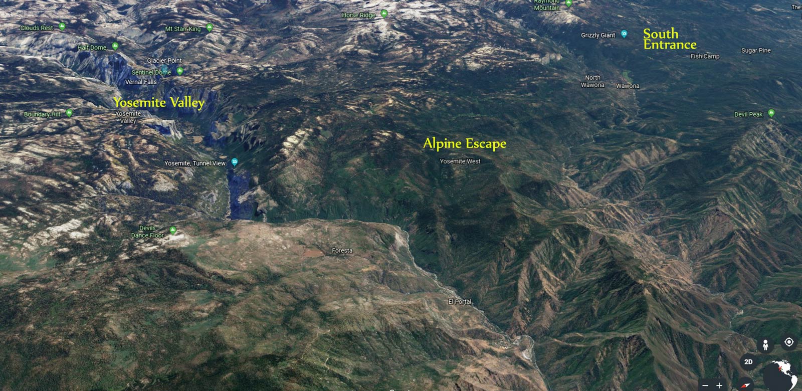
Area Map 
Neighborhood Detail Map
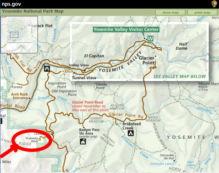
For the tech fiends in the audience, you can use longitude and latitude :-)
Longitude: -119.721935
Latitude: 37.648179
Directions
Coming from San Francisco, Sacramento or the East Entrance to the Park
- Take Highway 120 East (or 120 West if coming from the east) to Crane Flat and follow the signs to Yosemite Valley. Crane Flat is your last gas.
- Upon entering Yosemite Valley proper, you will have to take a right onto the one-way road around Yosemite Valley. You will immediately cross Pohono Bridge. Follow the directions from Yosemite Valley from there.
- In the winter, it is better and usually faster to go south to Merced and take Hwy 140 through Mariposa and El Portal into Yosemite Valley. The grocery shopping is not as good, but the road is at lower altitude and rarely has snow.
Coming from Yosemite Valley
- From Yosemite Village, follow the Valley Loop road as if making to leave the park, until you reach the intersection where Hwys 120 and 140 enter the Valley. Turn left and cross Pohono Bridge. This is the only left turn after El Capitan.
- From Pohono Bridge, continue toward Bridalveil Fall and turn right, following signs to Hwy 41, Wawona or Fresno.
- Stay on Hwy 41 past Wawona Tunnel (fantastic views of Half Dome, especially at sunset)
- It’s about 7.5 miles from the Wawona Tunnel to the Yosemite West turn-off, which is the only road on the right for about 20 miles.
- Look for the Chinquapin intersection with some large parking areas, and white government buildings (including a restroom). There will be a road going up to the left toward Glacier Point or Badger Pass.
- The right turn into Yosemite West is about 0.2 miles past the Chinquapin intersection, and is marked with a big brown sign. If you start going downhill, you’ve missed it.
- Turn right onto Henness Ridge Road and then follow the “In the Neighborhood” directions.
Coming from the South Entrance via Los Angeles, Fresno, Oakhurst, Fish Camp, or Wawona
- Stay on Hwy 41 past Fish Camp and through the South Entrance to Yosemite National Park.
- Turn left (the road to the right leads to the Mariposa Grove of Giant Sequoias)
- Pass the town of Wawona (a historic Victorian-style hotel, gas station and gift shop on the right; golf course to your left). Wawona is your last gas on this route.
- The Yosemite West turn off is ~12.5 miles from Wawona just past the apex of the road. The Nature Bridge Educational Campus is on your left and the entrance to the neighborhood is just after you see the campus. It is the the only left turn for over 20 miles and the first buildings you will see after leaving Wawona.
- If you get to a big intersection with white buildings (restrooms!) and a road leading to the right you have gone about 0.2 miles too far. Pull into one of the parking areas and get turned around.
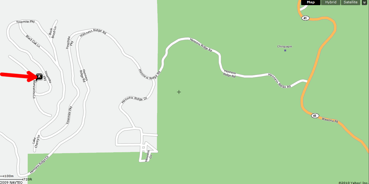
In the Neighborhood
The total distance from where you leave Highway 41 until you arrive at the house is 2.7 miles. Numbers in parentheses are cumulative mileages from the intersection with Hwy 41.
- First Y intersection: turn right — at the mailboxes (0.7 mi from Hwy 41).
- Second Y intersection just past the guard rail (1.1 mi): turn right and head down a steep hill. Use caution in winter. Slow way down.
- First T intersection (1.7 mi): turn right — left is a cul de sac. Follow this up, around a large horseshoe bend, and back downhill again. You will pass Buck Brush on your right and Black Oak on your left. Stay on Yosemite Park Way.
- Second T intersection (2.7 mi): turn right — again left is a cul de sac.
- Alpine Escape is the second house on the right — a tan house between a gold-colored house and a large log house. Park in the FIRST driveway (the narrow one directly in front of the front door, not the one with the parking meter on the side of the house).
Remove all food, trash and scented items from your car. Bears will destroy your car door and perhaps your car interior to get at food and this will result in the bear being put down by rangers. Protect your car and our bears by bringing all food inside.
Kick off your shoes, relax and have a great stay in Yosemite!